

By John Cavitt
John Cavitt is a Distinguished Professor of Zoology at Weber State University in Ogden, Utah. For over two decades, his research has focused on the ecology and conservation of Great Salt Lake birds. He has tracked shorebirds from Utah to the coast of Mexico, banded birds in Siberia, and spent more field seasons than he can count watching a lake he loves grow smaller. He writes and speaks regularly on Great Salt Lake conservation and can be found on Instagram @birdecologyguy and LinkedIn at linkedin.com/in/johnfcavitt
When the Water Reaches the Field
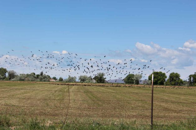
Come spring and summer, my favorite drive is the rural backroads of Weber and Box Elder counties. Invariably, I will spot a John Deere 4020 tractor parked along the edge of an alfalfa field, a cue that I have learned often precedes an avian spectacle. Northern Utah farmers are captive to the rhythm of irrigation this time of year, and the tractor usually means someone is about to open a headgate. A once-dry field then transforms into a shallow, moving sheet of last winter’s mountain snowpack.
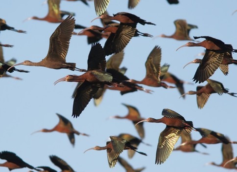
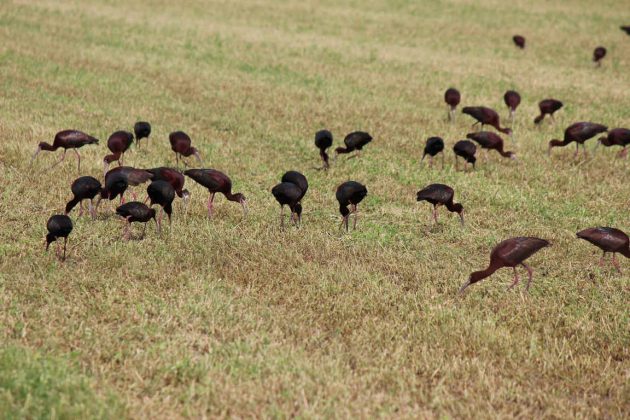
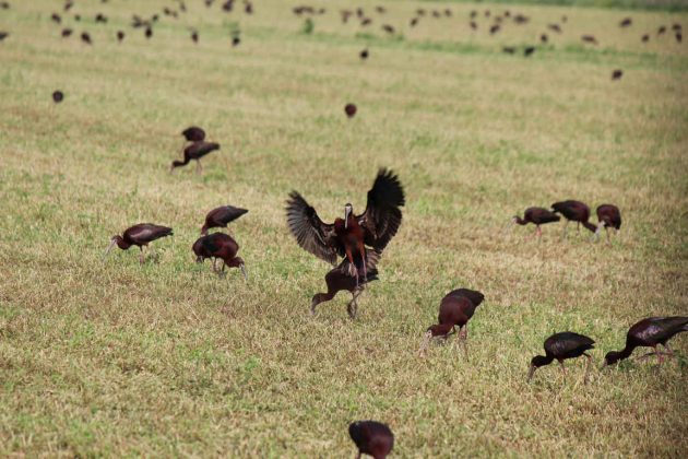
The avian response is not immediate, but it does not take long. Dark, iridescent birds circling high above begin descending, and before long hundreds of White-faced Ibis (Plegadis chihi) are dropping in to feast on the earthworms and soil invertebrates driven from their burrows by the rising water (Figure1, 2). As many as 47,000 breeding pairs have been known to nest in the wetlands surrounding Great Salt Lake[1]. The ibis are consistently first to arrive, soon joined by wheeling flocks of Franklin’s Gulls (Leucophaeus pipixcan) and California Gulls (Larus californicus). For an avian ecologist, it is a display I never tire of watching. For anyone tracking the decline of Great Salt Lake, it is an unsettling paradox.
Figure 1
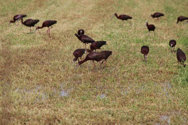
Figure 2
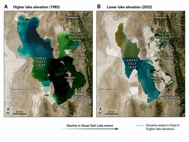
As a terminal lake with no outlet, Great Salt Lake loses water only through evaporation. Fed by the Bear, Weber, and Jordan rivers, it serves as a critical stopover on the Pacific Flyway for over 10 million migratory birds each year. Sustained upstream diversion has now pulled the lake below any elevation recorded since measurements began in 1903 (Figure 3). That retreat has exposed hundreds of square miles of sediments that contain arsenic and other contaminants, and it has pushed salinity in parts of the lake toward levels the brine shrimp and brine flies at the base of its food web are struggling to tolerate. This steady decline, rather than any single event, turns a routine irrigation season into a matter of genuine ecological consequence.
Figure 3
The Crop That Drinks A Lake
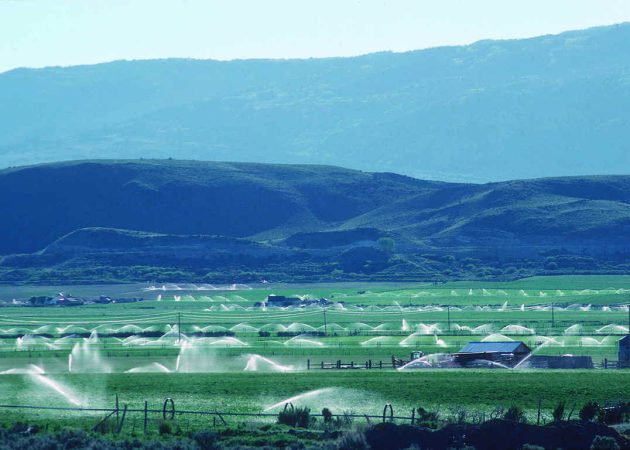
The issue comes down to an accounting problem. The basin keeps a ledger designed to allocate water among users rather than to sustain a terminal lake, and the lake sits at the bottom of it, receiving whatever is left after every upstream user has taken a share. According to recent data from the Great Salt Lake Strike Team[2], human use withdraws roughly 2.3 million acre-feet per year from the account. Public attention frequently focuses on urban lawns and municipal consumption, but the largest line item by far is agriculture: 65.0% of that total, or 1.5 million acre-feet annually. Alfalfa alone occupies roughly 47.5% of Utah’s irrigated cropland and requires up to 4 acre-feet per acre in a single growing season (Figure 4A, B).
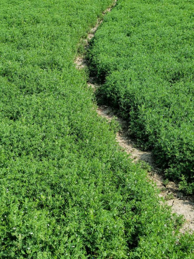
To put that volume in perspective, one acre-foot covers an acre a foot deep, or roughly 326,000 gallons. Because alfalfa requires about 75% more water per acre than barley or other spring grains, growing it in Utah consumes more water annually than every city and town in the state combined, as much as all 3.5 million residents use.
For decades, the conservation narrative has been straightforward: upstream agricultural diversions are drying up the basin, having already reduced natural inflows by approximately 39% and lowered the lake’s volume by up to 64%. Yet some species have adapted to this heavily modified hydrology.
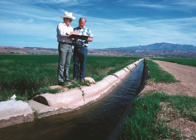
Because human development has altered most of the natural freshwater wetlands along the lake’s eastern margin, ibis have increasingly turned to agricultural fields as an artificial foraging network. Alfalfa in northern Utah is largely flood irrigated, with river water diverted through unlined dirt canals until the whole field sits under several inches of water, and ibis have come to rely on these temporary wetlands to sustain their breeding populations (Figure 5). The very practice that starves this terminal lake is simultaneously feeding one of the region’s most abundant migratory birds.
The Efficiency Illusion
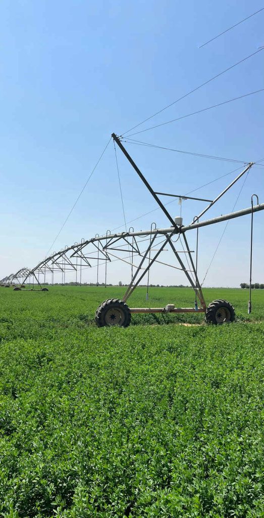
Agriculture accounts for the majority of diversions from Great Salt Lake inflows, and no solution that leaves it untouched can work. To stabilize the lake, Utah has distributed $150 million to $200 million in matching grants through its Agricultural Water Optimization Program, helping farmers replace flood irrigation with center-pivot sprinklers, the massive wheeled spray arms that rotate over crops (Figure 6). The state reports that completed projects have yielded over 125,000 acre-feet of annual savings.
On paper, the upgrade is a clear victory. In practice, it exposes a counterintuitive paradox: highly efficient irrigation may actually decrease the water returning to the terminal basin.
Traditional flood irrigation is messy, but its inefficiencies serve a vital hydrological function. When a farmer floods a field, the crop consumes only a portion of the water, and the remainder either seeps down to recharge shallow aquifers or trickles back into surface channels as return flow, in either case eventually reaching the lake. Center-pivot sprinklers deliver water directly to the root zone, so the crop consumes nearly every drop applied. An optimized field can therefore increase net depletion while leaving no return flow to feed the tributaries.
Then there is the law itself. Western water law operates under the Prior Appropriation Doctrine, a “first in time, first in right” framework established in the 1800s that treats water rights as private property. A right is legally defined by “beneficial use,” meaning the water must be diverted and applied to an economic purpose such as agriculture or mining to maintain ownership. Historically, leaving water in a river to protect an ecosystem did not qualify.
Since 2022, the state has expanded legal pathways to dedicate water to the lake, so the binding constraint is no longer statutory. Conserved water still has to be quantified, transferred, and shepherded past every intervening claim between the headgate and the shoreline.
Compounding this is the shadow of forfeiture. Nonuse applications exist, but the default rule is unforgiving: an owner who fails to put a full allocation to beneficial use for seven continuous years faces total loss of that right, which legally rewards farmers for maximizing diversions. Without strict downstream tracking, water saved upstream is simply left in the river, where it is likely to be intercepted by the next junior right holder before reaching the lake.
An efficiently irrigated alfalfa field, then, offers no foraging benefit to an ibis and no guarantee that a single drop of the savings reaches the lake.
Seven Feet in Eight Years
On September 24, 2025, Utah Governor Spencer Cox signed the Great Salt Lake 2034 Charter at the Eccles Wildlife Education Center on Farmington Bay (Figure 7), one of the wetlands where my students and I have spent two decades working on shorebirds and colonial waterbirds. His commitment was specific: restore the lake to a healthy elevation of 4,198 feet by 2034, the year Salt Lake City hosts the Winter Olympics for a second time. The announcement arrived with $200 million in private pledges split between Ducks Unlimited and Great Salt Lake Rising.
Figure 7

That elevation is not arbitrary. It comes from the 2013 Great Salt Lake Comprehensive Management Plan, which found that a range of 4,198 to 4,205 feet best balances the basin’s competing interests, close to the lake’s long-term historical average of roughly 4,200 feet. The target is better understood as a return to the lake’s own baseline than as a new standard.
The Strike Team’s February 2023 Policy Assessment recommended that the state formally adopt 4,198 feet as its measurable target, language the legislature considered but declined to enact as a binding resolution that same year. That distinction matters: a target written into law carries enforceable consequences for missing it, while an aspirational one can be redefined as the deadline nears. Below 4,192 feet, the state’s own criteria treat the lake as triggering serious adverse effects, roughly where the south arm sits today. The charter asks Utah to climb out of a zone its own scientists have flagged as harmful and into a range they spent a decade defining as sustainable.
The lake’s south arm closed the water year[3] at 4,191.1 feet, the third-lowest year-end elevation since record-keeping began in 1903, so the charter is asking for nearly seven vertical feet in under a decade. Under the Strike Team’s latest modeling, an additional 800,000 acre-feet each year would raise the mean projected elevation to roughly 4,196.9 feet by 2034, still about a foot below the healthy range. The mean reaches 4,198 feet over the longer term, although only 47 percent of the 2055 simulations fall within it.
Measured against that benchmark, progress is sobering. From 2021 through 2025, Utah dedicated and delivered approximately 398,000 acre-feet to the lake, with a preliminary 2025 total of 163,468 acre-feet, still only about one-fifth of the additional annual inflow in the 800,000-acre-foot scenario. The state has genuinely improved its irrigation infrastructure, yet as Strike Team hydrologist Paul Brooks notes, that system was built to serve farms and cities, so conserved water must survive a gauntlet of competing legal claims to reach the lake.
The Future Has Already Happened
We do not need to model what happens if the lake keeps shrinking, because the outcome is already recorded. Other saline lakes have gone down this road and shown, in very different ways, how the story ends.
The starkest example is the Aral Sea, once the fourth largest lake in the world, on what is now the Kazakhstan-Uzbekistan border. Beginning in the 1960s, Soviet planners diverted roughly three-quarters of its inflow to irrigate cotton, rice, and, notably, alfalfa. The fishing industry that once employed tens of thousands collapsed as salinity climbed, the last commercial catch was recorded in 1983, and the ship sturgeon and the Aral trout went extinct soon after. By 2007, the sea had lost roughly 90 percent of its volume, splitting into hypersaline remnants surrounded by the Aralkum, a new desert laced with agricultural chemicals that now generates dust storms linked to respiratory illness across the region (Figure 8).
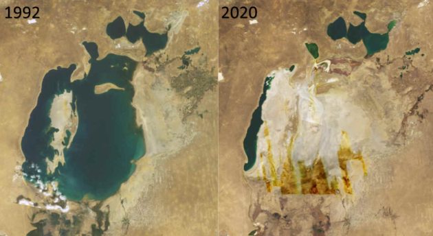
Closer to home, Owens Lake tells a similar story on a smaller scale. Los Angeles began diverting the Owens River into its aqueduct in 1913, and by 1926 the 110-square-mile lake was a dry alkali flat. Its exposed bed became the largest single source of carcinogenic particulate pollution in the country, severe enough that the EPA forced the city’s water utility to act in 1998. The utility has since spent roughly $2.5 billion covering nearly 49 square miles of lakebed with gravel, managed vegetation, and shallow flooding, cutting dust emissions by more than 99 percent. It is a permanent maintenance obligation with no end date, though that mitigation has at least become productive shorebird habitat.
A third saline lake shows that the story does not have to end in desert and dust. Mono Lake, in California’s Eastern Sierra, dropped 45 feet between 1941 and 1982 as Los Angeles diverted its tributary streams. The decline exposed a land bridge that let coyotes reach Negit Island and prey on one of the largest California Gull colonies in the state. In 1979, the National Audubon Society and the Mono Lake Committee sued, arguing that the public trust doctrine, now invoked in litigation over Great Salt Lake, obligated the state to protect the lake’s ecological value even against long-standing water rights.
The California Supreme Court agreed in 1983, and in 1994 the State Water Resources Control Board issued Decision 1631, which did something Utah has not yet done for Great Salt Lake: it set a legally binding target elevation of 6,392 feet and tied Los Angeles’s diversions directly to it. Exports remain capped until the lake is healthy. The decline stopped, Negit Island’s predator bridge went back underwater, and the lake now anchors one of the most productive stopovers on the Pacific Flyway. Mono Lake is not fully healed and still sits roughly eight feet below its mandated target (Figure 9). But it stopped falling and has been rising, because the target came with the force of law behind it.
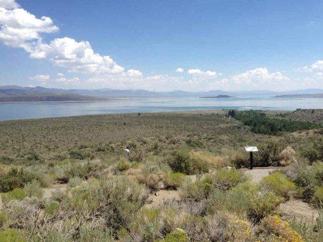
Moving the Right Water
Every acre-foot redirected toward the Watershed Enhancement Trust[4] is an acre-foot a canal company, a mineral operator, or a municipal district has grown accustomed to treating as its own, protected for more than a century by a doctrine built to reward the first user rather than the healthiest system. I am skeptical of anyone promising a single, painless fix for this basin. Having watched this hydrology for twenty years, though, I am convinced that a viable path depends on treating water rights, not just water molecules, as the asset that must move downstream.
Agriculture must remain the primary focus, but the choice of tools matters, and the most promising is split-season leasing. Alfalfa typically yields three to four cuttings per year, and the earliest carry the highest nutritional value and financial return (Figure 10). Under a split-season contract, a farmer continues flood irrigation through April and May and takes those first two cuttings, and that structural inefficiency provides critical early-season foraging habitat for returning ibis. The farmer then lets the crop go dormant and leases the remaining water right to the Great Salt Lake Watershed Enhancement Trust. The Strike Team estimates this could yield 200,000 to 300,000 acre-feet annually, the largest realistic contribution among agricultural options on the table.
Figure 10
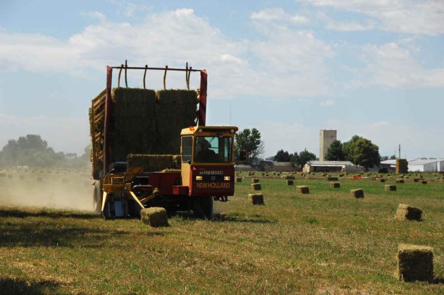
Beyond leasing, the state must require that every dollar of public matching funds for irrigation modernization carry a permanent legal dedication of the verified savings, because without that mechanism efficiency gains remain vulnerable to interception by junior right holders. State dollars stretch furthest, however, in temporary fallowing contracts and crop substitution. Shifting fields from alfalfa to winter wheat reduces depletions at $148 to $276 per acre-foot, compared with $688 to $806 for center-pivot upgrades. With the lake needing an additional 800,000 acre-feet each year, cost determines how far a limited pool of conservation dollars can go.
Agriculture cannot carry this burden alone. Municipal and industrial users are responsible for closer to 26 percent of basin depletions, and outdoor turf watering accounts for 97 percent of that consumption. For much of my time in Utah, two water lines served my home: culinary water, piped indoors and billed by the gallon, and unmetered secondary irrigation water delivered at a flat seasonal rate, an all-you-can-eat buffet paid for at the door with no reason to stop eating. The predictable result is overwatering to keep non-native Kentucky bluegrass alive in a desert (Figure 11). Universal secondary metering paired with targeted turf buyback programs are the only tools positioned to recover a meaningful share of that volume, and unlike agricultural savings, this water is diverted much closer to the point of use.
Figure 11
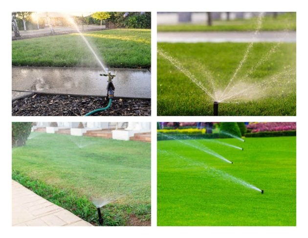
The mineral extraction industry has already demonstrated that enforceable reductions are possible. Operators such as Compass Minerals and Morton Salt, which collectively hold water rights exceeding 600,000 acre-feet, draw lake brine into solar evaporation ponds, where it passes directly into the air. These operations cut annual depletions from 186,000 acre-feet in 2020 to 77,000 in 2024 and have agreed to forgo substantial future allocations if the lake returns to healthy levels. An entire industry accepting enforceable limits on its own rights sets a more valuable precedent than any new technology.
Then there is the pressurized freshwater aquifer recently found beneath the lake’s eastern margin, an extraordinary geophysical find that some have floated as a way to rewater the lake from below. It is not. Nothing about this reservoir changes the arithmetic of the basin’s ledger. Bill Johnson, the University of Utah hydrogeologist leading the research, says plainly that the water appears to be a remnant of ancient Lake Bonneville, recharging on a geologic timescale rather than a human one. Because it already feeds the lake through natural seepage, pumping it out to spray across dry playa risks draining the very system it is meant to help. Using it to wet isolated dust hotspots is a legitimate public health tool, but it does not relieve us of the need to reduce upstream diversions.
The Hill Above the Lake
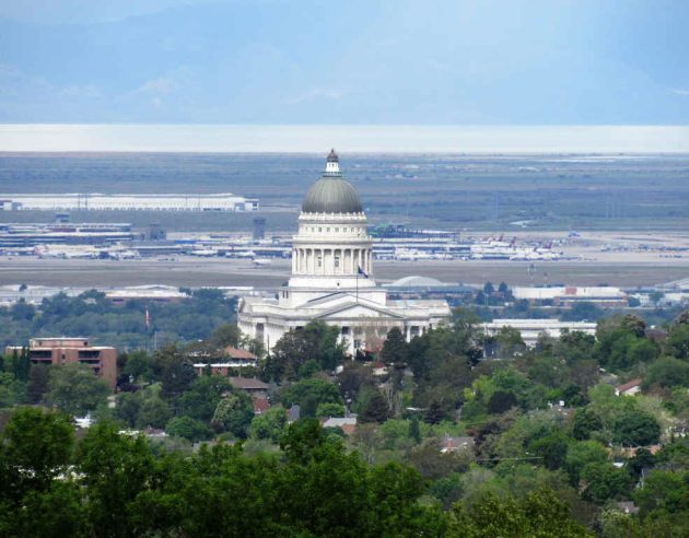
All of this will be decided inside the domed statehouse on the hill overlooking the lake, where the political calculations are already underway (Figure 12). Agricultural, mineral, and real estate interests each hold a direct financial stake in the status quo, and it takes political courage to impose enforceable limits on constituencies that are organized, well funded, and deeply embedded in state politics. Yet asking leaders to choose the harder path over the comfortable one is not unreasonable; it is their job.
Figure 12
Stacked together, backed by enforceable dedication rather than voluntary goodwill, and spread fairly across every sector that depletes the basin, these measures offer a path toward 4,198 feet. At the scale of a terminal basin, efficiency is not conservation unless it reduces depletion and the conserved water is protected all the way to the lake. A sprinkler, a meter, or a publicly funded upgrade is only a tool, and success is measured not by how much less water leaves a headgate but by how much more reaches the shoreline.
Next spring, I will again pull over on a Weber County road and watch mountain runoff spread across an alfalfa field. The ibis will descend as they always have, their dark wings flashing green and bronze in the morning light. It will be beautiful. That is what makes the scene so deceptive. Abundance in one flooded field can conceal the unraveling of the watershed that sustains it.
The ibis cannot testify before a legislative committee, and the lake cannot defend its own water right. The students I take to Farmington Bay should inherit more than a well-documented ecological collapse. They should inherit a living lake, not another aspiration from the hill above it. What Great Salt Lake needs is water, protected all the way home.
[1]Cavitt, J. F., Jones, S. L., Wilson, N. M., Dieni, J. S., Zimmerman, T. S., Doster, R. H., & Howe, W. H. (2014). Atlas of breeding colonial waterbirds in the interior western United States [Website]. U.S. Department of the Interior, U.S. Fish and Wildlife Service. https://departments.weber.edu/avianecologylab/WesternWaterbirdAtlas/atlas.html
[2] The GSL Strike Team is a science panel that functions in a technical advisory role for the State of Utah.
[3] Water year- the 12-month accounting period running Oct 1 (natural low point in hydrological cycle) through Sept 30.
[4] Is a $40 million dedicated water trust managed by National Audubon and the Nature Conservancy, established to protect and restore the water quantity, water quality, and surrounding wetland habitats of the Great Salt Lake.












Leave a Comment